Want your own copy of the 1825 Lafayette map?
High-quality reproductions of the map are available – click here to visit the Lafayette Shop!
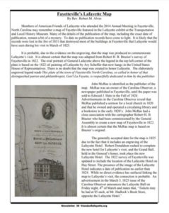
19th Century Maps Show Streets of Young Fayetteville
From the Fayetteville Observer
Sunday, March 1, 2015 10:31 pm | Updated: 2:27 pm, Mon Mar 2, 2015.
Paul Woolverton Staff writer
When retired Army Col. William Dougald MacMillan IV died in July 2013, he left a legacy of Fayetteville history: a cache of 34 maps of the town printed in the early 1820s.
Soon those maps will be put up for of sale, said lawyer Hal Broadfoot, who has been assisting MacMillan’s family with the estate. Two of the maps, one restored, one not, were presented Sunday afternoon at the Lafayette Society’s annual meeting at the Holiday Inn Bordeaux.
History buffs and others at Sunday’s luncheon leaned close to squint at the water-stained and yellowed papers. Some looked for the streets they and their friends live on today.
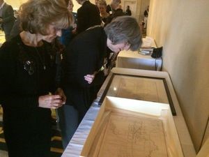
Ginette Moreau and Karen Irizarry examine the Lafayette map.
“It’s kind of neat seeing Fayetteville, recognizing some of those streets,” said Karen Irizarry. “It’s kind of neat seeing the city grow up.”
The maps were printed from hand-engraved printing press plates and plainly lay out in two neat grids the original street plans of the former towns of Cross Creek and Campbellton. The communities merged in 1783 to become Fayetteville.
Campbellton was on the bank of the Cape Fear River and today is barely recognizable compared with what is on the map. The streets of Cross Creek form what is now known as downtown Fayetteville. That part of the map has names familiar today. Hay, Person, Green and Gillespie streets meet at the Town House Square, site of the Market House.
Dozens of buildings are marked, and some named. Most burned in a great fire in 1831, Broadfoot said.
It’s uncertain how many of these maps have been printed. Broadfoot thinks there are about 20 other copies accounted for. The Library of Congress has one, and a high-resolution copy can be downloaded from its website.
MacMillan inherited these 34 copies from his wife, the former Tori Lilly, Broadfoot said. “His wife, who died before him, was the great-great-great granddaughter of John McRae, who published the map,” he said.
“Published by John McRae, Fayetteville,” is written across the bottom. McRae was one of the early publishers of the Carolina Observer newspaper, which later became The Fayetteville Observer, Broadfoot said.
Historians aren’t sure why the maps were made, Broadfoot said. They may have been intended to promote the 1825 visit of the Marquis de Lafayette, the French aristocrat and American Revolutionary War general for whom Fayetteville was named in 1783.
There are clues on the map, said Chuck Schwam, treasurer of the American Friends of Lafayette.
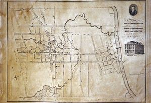
The “Lafayette map” of Fayetteville, North Carolina
In the upper-right corner there is picture of Lafayette, copied from a portrait now hanging in the U.S. Capitol, he said.
Below the picture is written, “This plate of the town of Fayetteville North Carolina, so called in honor of that distinguished patriot and philanthropist, Gen’l La Fayette, is respectfully dedicated to him by the publisher.”
And below that is a drawing of the Lafayette Hotel, which was on Hay Street and burned in the 1831 fire.
MacMillan’s family is still deciding when and how the maps will be sold, Broadfoot said. Maps from this lot have been previously estimated to be worth $1,000 to $5,000 each to collectors, he said, but he has not seen any sales records to indicate their value. He plans to show them to an appraiser.
Staff writer Paul Woolverton can be reached at woolvertonp@fayobserver.com or 486-3512.